


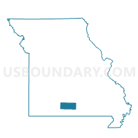
Washington Voting District, Douglas County, Missouri
About
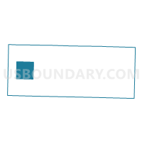
Outline

Summary
| Unique Area Identifier | 607737 |
| Name | Washington Voting District |
| County | Douglas County |
| State | Missouri |
| Area (square miles) | 36.10 |
| Land Area (square miles) | 36.09 |
| Water Area (square miles) | 0.00 |
| % of Land Area | 99.99 |
| % of Water Area | 0.01 |
| Latitude of the Internal Point | 36.93907590 |
| Longtitude of the Internal Point | -92.79533940 |
Maps

Graphs
Select a template below for downloading or customizing gragh for Washington Voting District, Douglas County, Missouri


Neighbors
Neighoring Voting District (by Name) Neighboring Voting District on the Map
- Benton No. 1 Voting District, Douglas County, MO
- Benton No. 2 Voting District, Douglas County, MO
- Buchanan Voting District, Douglas County, MO
- Campbell Voting District, Douglas County, MO
- Findley Voting District, Douglas County, MO
- Lincoln Voting District, Douglas County, MO
- Spencer Voting District, Douglas County, MO
- Spring Creek Voting District, Douglas County, MO
Top 10 Neighboring County Subdivision (by Population) Neighboring County Subdivision on the Map
- Benton township, Douglas County, MO (4,308)
- Spring Creek township, Douglas County, MO (844)
- Washington township, Douglas County, MO (700)
- Findley township, Douglas County, MO (609)
- Lincoln township, Douglas County, MO (478)
- Campbell township, Douglas County, MO (468)
- Spencer township, Douglas County, MO (385)
- Buchanan township, Douglas County, MO (317)